Inserting new sensors
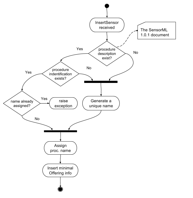
With regards to the OGC SOS 2.0.0 Transactional Extension istSOS supports the insertSensor request. The database will be created on the go. During an InsertSensor the minimal info will be stored. Later when the InsertObservation will be done, the rest of the data store will be built.

This is an example of a minimal insertSensor request:
<swes:InsertSensor
    xmlns:swes="http://www.opengis.net/swes/2.0"
    xmlns:sos="http://www.opengis.net/sos/2.0"
    xmlns:swe="http://www.opengis.net/swe/1.0.1"
    xmlns:sml="http://www.opengis.net/sensorML/1.0.1"
    xmlns:gml="http://www.opengis.net/gml"
    xmlns:xsi="http://www.w3.org/2001/XMLSchema-instance"
    xmlns:xlink="http://www.w3.org/1999/xlink"
    service="SOS"
    version="2.0.0">
    <swes:procedureDescriptionFormat>http://www.opengis.net/sensorML/1.0.1</swes:procedureDescriptionFormat>
    <swes:procedureDescription>
        <sml:SensorML/>
    </swes:procedureDescription>
    <swes:observableProperty>urn:ogc:def:parameter:x-istsos:1.0:meteo:air:temperature</swes:observableProperty>
    <swes:metadata>
        <sos:SosInsertionMetadata>
            <sos:observationType>http://www.opengis.net/def/observationType/OGC-OM/2.0/OM_Measurement</sos:observationType>
            <sos:featureOfInterestType>http://www.opengis.net/def/samplingFeatureType/OGC-OM/2.0/SF_SamplingPoint</sos:featureOfInterestType>
        </sos:SosInsertionMetadata>
    </swes:metadata>
</swes:InsertSensor>
The procedure and the offering id will be generated automatically by istSOS. If you want some more control over the sensor insertion then you should describe the sensor (or process) using the SensorML 1.0.1 specification into the procedureDescription block.
Usage of the InsertSensor XML
swes:observableProperty
The swes:observableProperty elements (one or more) are used to configure the actual observable properties of this new offering. This is the declaration of how the O&M Observation will be when the sensor (or process) will produce the actual measurements.
sos:observationType
IstSOS supports various observation types, with regards to the observation type definition, measurements can be sent as:
Note
The final relation between observed properties and the observation types will be done later during the transmission of an O&M Observation within the first insertObservation request.
http://www.opengis.net/def/observationType/OGC-OM/2.0/
- OM_Observation
- OM_Measurement
- OM_CategoryObservation
- OM_ComplexObservation
- OM_CountObservation
- OM_DiscreteCoverageObservation
- OM_GeometryObservation
- OM_PointCoverageObservation
- OM_TemporalObservation
- OM_TimeSeriesObservation
- OM_TruthObservation
sos:featureOfInterestType
With the <sos:featureOfInterestType/> definition, offerings are configured to handle different kind of the geometry representing the feature of interest.
Take a look here at the schema:
SF_SamplingPoint
http://www.opengis.net/def/samplingFeatureType/OGC-OM/2.0/SF_SamplingPoint
This type is usually used to represent an in-situ fixed procedure. For instance a fixed monitoring sensors, like a weather station. The shape is a gml:Point element.
<gml:Point
    gml:id="st2p">
    <gml:pos>-30.706 134.196 272.</gml:pos>
</gml:Point>
SF_SamplingCurve
http://www.opengis.net/def/samplingFeatureType/OGC-OM/2.0/SF_SamplingCurve
This type is usually used to represent observation boreholes, trajectories, traverses, etc. The shape is a gml:LineString element.
<gml:LineString
    gml:id="pr1_ls1"
    srsName="urn:ogc:def:crs:EPSG:6.8:4347">
    <gml:pos>-30.711 134.205 321.</gml:pos>
    <gml:pos>-30.710 134.204 315.</gml:pos>
    <gml:pos>-30.709 134.203 303.</gml:pos>
    <gml:pos>-30.708 134.201 296.</gml:pos>
    <gml:pos>-30.706 134.196 272.</gml:pos>
    <gml:pos>-30.703 134.197 271.</gml:pos>
    <gml:pos>-30.702 134.199 280.</gml:pos>
</gml:LineString>
SF_SamplingSurface
http://www.opengis.net/def/samplingFeatureType/OGC-OM/2.0/SF_SamplingSurface
This type is usually used to represent observation boreholes, trajectories, traverses, etc. The shape is a gml:Polygon element.
<gml:Polygon gml:id="Polygon_ssf_094D1FDB65BC787B8AC339F4029B622A86EED5EC">
  <gml:exterior>
    <gml:LinearRing xsi:type="gml:LinearRingType">
      <gml:posList srsName="http://www.opengis.net/def/crs/EPSG/0/4326">7.52 7.32 7.52 52.7 52.7 52.7 52.7 7.32 7.52 7.32</gml:posList>
    </gml:LinearRing>
  </gml:exterior>
</gml:Polygon>
SF_Specimen
http://www.opengis.net/def/samplingFeatureType/OGC-OM/2.0/SF_Specimen
A Specimen is a physical sample, obtained for observation(s) carried out ex situ, sometimes in a laboratory. OGC 10-026 (ISO 19156:2011) Clause 10.1
Describing the sensor with SensorML 1.0.1
swes:procedureDescription
According to the SOS standard, sensors (or processes) are described using the SensorML (1.0.1) specification. In istSOS the main purposes of SensorML [OGC 07-000] are to:
- Provide descriptions of sensors and sensor systems for inventory management
- Provide sensor and process information in support of resource and observation discovery
- Support the processing and analysis of the sensor observations
- Support the geolocation of observed values (measured data)
- Provide performance characteristics (e.g., accuracy, threshold, etc.)
- Provide an explicit description of the process by which an observation was obtained
- Archive fundamental properties and assumptions regarding sensor systems
You can feel free to use the SensorML specification as you want, mainly because the SML document will be saved as is. And will be returned when a describeSensor request is done.
Most of the metadata contained in the SML are not used for operational purpuses, but some elements if present will be parsed and used by istSOS in support of resource and observation discovery. In particular if you want to use a predefined system type (see System Types classification). A well formatted SensorML is necessary.
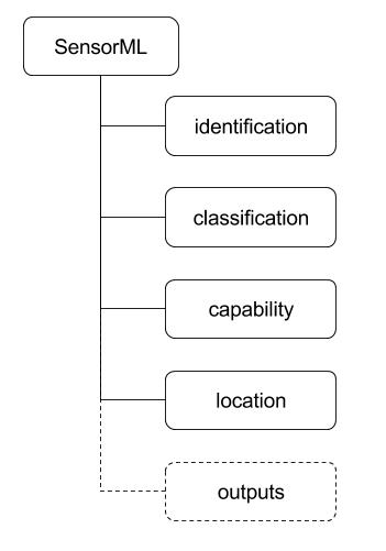
The next picture shows which elements are parsed in istSOS extracted from the procedureDescription element during an insertSensor request.

Identification
In the identification block you can define the procedure identifier that will be used to filter SOS requests. According to the standard defining the uniqueID is not mandatory and in the case an insertSensor without a uniqueID is sent, then istSOS will generate automatically an identifier.
<sml:identification>
    <sml:IdentifierList>
        <sml:identifier name="uniqueID">
            <sml:Term definition="urn:ogc:def:identifier:OGC:uniqueID">
                <sml:value>urn:ogc:def:procedure:x-istsos:1.0:LUGANO</sml:value>
            </sml:Term>
        </sml:identifier>
    </sml:IdentifierList>
</sml:identification>
Note
According to the OGC SWES [OGC 09-001], on each InsertSensor request istSOS will assign an auto generated name if a procedure identifier is not defined within the SensorML (OGC 09-001, REQ 50).
Classification
In the classification block the System Type is used to adopt some predefined operational behaviours (see System Types classification).
<sml:classification>
    <sml:ClassifierList>
        <sml:classifier name="System Type">
            <sml:Term definition="urn:ogc:def:classifier:x-istsos:1.0:systemType">
                <sml:value>pointObservation</sml:value>
            </sml:Term>
        </sml:classifier>
    </sml:ClassifierList>
</sml:classification>
Capabilities
The capabilities blocks can be used to assign the feature of interest and the offering id. The feature of interest id can be specified using an uri linking an existing feature of interest if a location is not given, otherwise a new feature of interest will be created.
<sml:capabilities name="offering">
    <swe:SimpleDataRecord>
        <swe:field name="offeringID">
            <swe:Text>
                <swe:value>breganzona</swe:value>
            </swe:Text>
        </swe:field>
    </swe:SimpleDataRecord>
</sml:capabilities>
<sml:capabilities name="featuresOfInterest">
    <swe:DataRecord>
        <swe:field name="featureOfInterestID">
            <swe:Text>
                <swe:value>breganzona</swe:value>
            </swe:Text>
        </swe:field>
    </swe:DataRecord>
</sml:capabilities>
Note
According to the OGC SWES [OGC 09-001] on each InsertSensor request a new Offering shall be created (OGC 09-001, REQ 49). IstSOS will generate a unique identifier if not given as in the capabilities part.
Location
The location is used to save the coordinates of where the sensor will be positionioned as his feature of interest if the sensor type is defined as in-situ-fixed.
<sml:location>
    <gml:Point srsName="EPSG:4326">
        <gml:coordinates>46.001470,8.919284,510.3</gml:coordinates>
    </gml:Point>
</sml:location>
Outputs
The outputs defined within the SensorML are not used to initialize the new offerings. According to the OGC SensorML Implementation Specification [OGC 07-000], SensorML is not intended to provide the framework for encoding the actual observation values. Within the SWE framework, the actual observation results should be encoded and transmitted within an O&M Observation instance or as a TML data stream. (OGC 07-000, 8.12.2).
The actual observable properties are defined within the swes:observableProperty elements.
